It's a long way to the top of Mt. Whitney
We got to the trail intersection between Discovery Pinnacle and Mt. Muir and I didn’t know whether to laugh, cry or vomit.
The hike that morning was a three-mile, 2,000 foot ascent from our campsite at Guitar Lake, elevation 11,500 feet.
For me it was the final day of a five-day, 50-mile hike from Onion Valley near Independence, Calif., to the top of Mt. Whitney which, at 14,505 feet, is the highest peak in the continental United States.
As a resident of Southern California and Nevada for 15 years I’d given plenty of thought to the concept of visiting the top of Mt. Whitney. Moving to Reno, in the shadow of the Sierra Nevada, only made the call more urgent.
An opportunity to join two experienced mountaineers, one of whom had ascended Whitney more than a dozen times in all seasons, is what prompted me to turn thought to action.
The intersection near Trail Crest, where the final segment to the summit branches off, was significant because it marked the spot where I would decide whether I was feeling good enough to continue the final 1.9 miles to the peak or turn and start heading for our exit at Whitney Portal.
Prior to that point I’d spent much of my time worrying about how my body would react to the altitude. I felt that for the trip to be a success I would need to reach the summit and my main concern was that altitude sickness would get in the way.
To deal with the anxiety I made sure to pace my hiking, pay close attention to my breathing, take plenty of rests and stayed hydrated. I also decided from the outset that instead of thinking about the peak of Whitney for four nights and five days I’d narrow my focus to whatever high pass was in front of me on any given day.
That meant the intersection between Guitar Lake and Whitney was my penultimate goal. Once I reached that spot in good shape the decision to continue to the summit or start hiking out would be an easy one. If I felt good, I’d go up. If not, I’d hike out.
I knew the early morning hike to the intersection would be cold, windy and exhausting. I wasn’t prepared to be overcome by emotion as well.
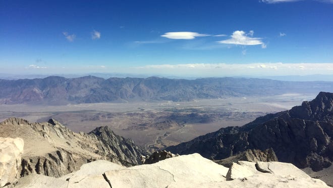
Standing at the intersection with Sierra Nevada peaks stretching to the horizon in every direction, including the passes and valleys I’d hiked the previous four days, was overwhelming.
My hiking partners, Peter Tremayne and Bob Williams, both of Reno, were ready to start the final stretch to the summit.
But first I wanted to savor the moment, gather myself and reflect briefly on the hike up to that point.
Onion Valley to Kersarge Basin
Distance: 6.5 miles
Elevation gain: 2,705 feet
High Point: Kearsarge Pass, elevation 11,760
My hike to Mt. Whitney started five days previous in Onion Valley near Independence, Calif.
That’s where Cris Chater, a longtime through-hiker who often goes by her trail name, Strider, dropped me off at the trailhead.
Two years ago Chater took over the Mt. Williamson Motel and Base Camp in Independence. Since then, she’s transformed it into a hiking-centric destination for the southern Sierra.

Not only did Chater add hiker-friendly touches to the motel, such as rides to the trailhead, she will haul resupplies to John Muir and Pacific Crest trail through-hikers on behalf of Sierra Nevada Bighorn Sheep Foundation.
Mt. Williamson also serves hot breakfast to guests each morning, an especially nice touch for people heading into the Sierra.
The plan called for me to hike into the Kearsarge Basin to meet and resupply Tremayne and Williams, who were through-hiking the John Muir Trail beginning at Tuolumne Meadows near Mammoth, Calif.
From the Onion Valley trailhead, elevation 9,200 feet, it’s about a seven mile hike to get into the basin, a trek that includes crossing over Kearsarge Pass, elevation 11,800 feet.

The trail starts heading up toward the pass right at the parking lot, which puts the hiker right into some demanding work from the start.
The good news is the trail is in good condition and the valley is a scenic backdrop. I hiked carrying enough water to get me to Gilbert Lake, which is the last easy water stop on the east side of Kearsarge Pass.
The first three miles go through wooded terrain and along Independence Creek until it reaches Gilbert Lake.
After Gilbert the trail cuts away from the water, climbs through the forest past two more lakes and ends up above treeline in a small, relatively flat area. It crosses the flat past another large lake deep in a granite basin before climbing the rest of the way to the top of the pass. It also marks the boundary for Kings Canyon National Park.
From the top of the pass the trail winds down into Kearsarge Basin. There it splits, with the trail on the right running along the north side of the basin and away from the lakes below. A trail to the left drops down to Kearsarge Lakes and Bullfrog Lake before intersecting the John Muir Trail.
There’s no camping allowed at Bullfrog Lake, but there are sites near Kearsarge Lakes.
Kearsarge Basin to Bubb’s Creek
Distance: 6.6 miles
Elevation gain: 1,232 feet
High point: 10,752 feet, Bubb's Creek camp
Day two was the easiest of my five days on the trail, at least for me. I was meeting Tremayne and Williams near Bullfrog Lake, which was just a mile or so down the trail from where I camped.
Williams and Tremayne were hiking down from Glen Pass, which they would cross that same morning.
From there we would hike down about 1,000 feet in elevation into Lower Vidette Meadow, then gradually up into Vidette Meadow toward our campsite at Bubb’s Creek.
This stretch of trail was largely wooded with plenty of shade and water. At one point we spotted a large buck that barely moved even as we shot photos and chatted.

The trail for most of the stretch stayed close to the creek which made getting water easy. As we reached the end of the day we set up camp just before the creek crossed the trail below Center Peak.
It was out nicest campsite of the trip, with large granite slabs to unfurl tents and gear and good tent pads. Nearby there were some steel lockers to make it easier for hikers to keep food safe from bears.
Bubb’s Creek to Tyndall Creek (over Forester Pass)
Distance: 9.9 miles
Elevation gain: 2,625 feet
High point: Forester Pass, elevation 13,150 feet
Day three was a stretch I’d been anticipating from the beginning.
The highlight of the day would be Forester Pass. At 13,200 feet in elevation it is the highest pass on the Pacific Crest Trail, which runs concurrently with the John Muir Trail in segments, and promised to be one of the most scenic parts of the trip.
The first mile or two of the day’s hike was largely forested and protected the wind.
Eventually, though, we climbed above the treeline. The elevation made for challenging breathing and higher exposure to sun and wind.

But it also meant great views of the peaks and crags that mark the southern boundary of Kings Canyon National Park and, looking behind us, Vidette Meadow.
The great thing about approaching Forester Pass from Vidette Meadow is the quality of the trail itself. For such a high pass the trail grade is smooth and not too severe.
Although it’s always demanding to carry a heavy pack over a mountain pass, it’s possible on Forester to work yourself into a nice rhythm that allows quick progress and even enjoyment of the climb.
As with most mountain passes, though, the trail does get steeper near the top and the final few switchbacks were a bit of a struggle, partly because of the altitude.
For people through-hiking the John Muir Trail reaching the top of Forester is a significant moment. It’s the final high pass before Whitney and marks the beginning of the end of their hike.

It felt like an accomplishment for me, too, at least in the sense that I was able to climb it without any altitude or fitness problems.
The top of Forester also marks the boundary for Sequoia National Park. It’s a small area with room for maybe 10 to 12 people to arrange themselves comfortably.
Unlike the smooth climb from the Kings Canyon side, the Sequoia side is a nearly straight drop of about 1,000 feet in elevation in the first quarter mile.
To make the drop hikers follow trail switchbacks carved into the ridge toward Tyndall Creek. I was glad to be descending at this point because a climb from this side would be steep and, if you were hiking it in the afternoon, completely exposed to intense western sun.

Near the bottom of the drop there’s an important historical marker many hikers overlook. On the left side of the trail (for downhill hikers) is a large boulder with a bronze plaque.
The plaque is a memorial for Donald I. Downs, who died on Sept. 2, 1930 died following a construction accident while working on the trail.
According to guidebook author Raymond Rippel, Downs died after having his arm crushed by a boulder that shifted due to a dynamite blast.
A doctor made the three day trip into the site. By then Downs’ injury had contracted gangrene prompting the doctor to amputate it at the shoulder.
The patient was then evacuated to a cabin near Tyndall Creek. Downs’ mother and two nurses joined the group at the cabin. But Downs’ condition deteriorated and he died in the cabin.

After taking a moment to reflect on Downs, our group continued to the bottom of Forester Pass and hiked over a treeless plateau dotted with lakes and meadows that in the late afternoon was subject to a warm, orange, glowing sunlight.
We camped that night in a cluster of trees near the intersection with a trail that heads north and over Shepherd Pass.
Tyndall Creek to Guitar Lake
Distance: 11.4 miles
Elevation gain: 2,353 feet
High point: Guitar Lake, 11,600 feet
The second-to-last day on the trail wasn’t a particularly difficult one. Before we started I thought the most significant part would be finally getting to Guitar Lake, our highest camp of the trip and the last stop before Whitney.
But that was before we crossed the Bighorn Plateau.
It’s a treeless plateau at about 11,500 feet in elevation. We reached it after hiking through a small forest of ancient Foxtail pines.
To walk across the plateau is to be reminded of your smallness and fragility relative to the landscape of the High Sierra.

Even in mild conditions the wind whips across the plateau and you can’t help but imagine what it must be like when the weather is rough.
It’s also where hikers get a brief glimpse of the top of Mt. Whitney from the west.
After the plateau the trail drops back into the forest and begins climbing again toward the Crabtree Ranger Station.
From there the trees start to thin as you make your way to Timberline Lake and, eventually, Guitar Lake.
The latter is completely above the treeline and at the bottom of a steep basin with Mt. Hitchcock looming to the south and Whitney to the northwest.

We situated our tents on a pad about 100 feet in elevation above the lake and away from the most popular sites closer to the water.
Our water came from a creek that flows from Arctic Lake down to Guitar Lake and our site, like the rest of the basin, was fully exposed to the weather conditions.

We were fortunate to be there on a mild day. But even in mild conditions we needed to keep close track of lightweight gear so it wouldn’t blow away. And we had to cook with our stoves up against piles of rocks previous people had stack to create breaks from the wind.
A 4 a.m. wakeup call to ascend Whitney the following day meant there wouldn’t be much time that evening to enjoy the basin, although we did get to enjoy a great sunset and moonrise before turning in.
Guitar Lake to Mt. Whitney and a long hike out
Distance: 15.9 miles
Elevation gain: 3,306
High point: Mt. Whitney, elevation 14,505 feet
Finally. The big day, which for us turned out to be even longer than the nine to 10 hours of trail time we expected.
Our plan was to wake up before dawn so we could eat, break camp and be ready to start hiking as soon as the sun rose. Many Whitney hikers start in the dark and as we were getting prepared we could see their headlamps slowly climbing the long switchbacks above the basin.
From the bottom of the basin it’s a straightforward hike up a well-maintained trail that includes fantastic views back to Guitar Lake and the Hitchcock Lakes.
The biggest challenge of this stretch was dealing with conditions. Cold winds necessitated covering up as much as possible. But hauling a heavy pack uphill from 11,500 to 13,500 feet is a lot of work and sweat.

As a result I found it hard to maintain my body heat at a comfortable level. But other than that it was uneventful until we made it to the ridgetop and the final intersection before the summit.
The intersection offers hikers three choices. Take the cherry stem 1.9 miles up to Whitney Summit, head down to Guitar Lake or head down the east side of the ridge toward Whitney Portal.
It’s also where backpackers who plan to summit can drop their big packs and reduce their load to a day pack and some water.
This is where I stopped to gather myself before heading making the call to head up to the summit. In addition to dropping my pack I was able to let go of my worries that I wouldn’t be capable of making it to this point.
With that concern behind me for the first time on the trip I was truly able to ponder the magnificent landscape before me and realized it was too much to comprehend in one take.

It took a minute or so to regain my focus and turn to the trail ahead which, as it turned out, still had some challenges.
The initial quarter-mile from the intersection involves some easy switchbacks and can lull hikers into thinking the remainder of the trip to the summit will be a pleasant stroll.
That’s not the case. Not even close.
As the ridge narrows the trail gets steeper and more rocky. The route squeezes hikers between the needles that make up the ridgeline and a steep, vertical drop to the east.
At points between the needles hikers can also peer over a vertical drop to the west. Two of the three deaths on Mt. Whitney in the past three years have involved people falling from the trail along this stretch.
According to the National Park Service in 2013 a 60-year-old man died after experiencing the symptoms of altitude sickness. Weak and nauseous, he leaned over the side of the trail to vomit, lost consciousness and fell to his death.

In 2014 a 75-year-old man hiked up from Guitar Lake in deteriorating weather conditions. As he was making his way toward the summit he walked off the edge of the trail.
Sequoia District Ranger Dave Fox said the hiker was unprepared for the poor weather conditions.
In addition to natural hazards, this section of trail also involves dealing with other hikers. That’s because hikers coming up from Guitar Lake merge in with hikers coming up from Whitney Portal, which is by far the most popular route.
You’ll need to be patient in the narrow stretches to allow slower hikers time to negotiate the obstacles and get past hikers coming from the opposite direction.
Eventually the trail turns back to the north and east and onto a flatter, wider ridge that takes you to the summit.

After all that hiking it’s a little strange to finally arrive. My summit experience was brief. I took some photos, shook hands with my hiking partners and poked my head into the stone shelter.
I probably spent about 15 to 30 minutes on the summit. It felt good to enjoy being at the top of the highest peak in the lower 48 states and to have made the trip without too much difficulty.
But we still had a long way to go to reach Whitney Portal. Hiking out, it turned out, was actually the most difficult part of the day.
I picked my way back through the trail rubble toward the intersection. As I neared the switchbacks at the easiest section I realized I’d hiked ahead of my partners and stopped to wait.
I’m glad I did. It turned out Williams had a sudden, and thankfully brief, bout of weakness and fatigue.
While he rested to wait it out Tremayne and I decided it would be best if I went ahead and retrieved Williams’ pack so I could haul it to the high point about a quarter mile from the intersection in the direction of Whitney Portal. That way Williams wouldn’t have to do any more ascent carrying the big pack.

Shortly after I got both his and my pack to the peak, Williams came along ahead of Tremayne having regained his strength.
From the trail crest we started down an extensive number of short switchbacks toward the Whitney high camp, a spot where many hikers from Whitney Portal spend the night before completing their summits. Others hike all the way up from Whitney Portal and back out in one day, which I wouldn’t recommend if for no other reason than it would be a grueling day with little time to enjoy the experience.
Just below the high camp the setting sun caught up with us and our progress slowed greatly. Although the trail to Whitney Portal is popular there are sections that are not in great condition.
It can be steep, hikers need to cross slabs covered in loose pebbles and it is strewn with rocks and crossed by tree roots.
To reduce the risk of an accident in the dark we used headlamps and walked slowly for the remaining part of the hike and didn’t make it to Whitney Portal until nearly 10 p.m.
Make it we did, though. And after some time to reflect on the trip here’s what I learned and would apply next time.
Hike in the long way. Hiking up and back from Whitney Portal would be a grind whether you do it in one or two ways. Hiking in from the backcountry as part of a longer backpacking trip gives you more time to acclimate to the altitude.

Take your time. I expected the final 1.9 miles with a day pack would be much easier than my previous ascents with a full pack. It wasn’t. The trail is rugged and you need to concentrate. It’s not a place where you would want to get injured in a slip or fall.
Pay attention to your body. If you feel winded take a rest. Drink lots of water. Maintain your calorie intake. Dehydration and fatigue can contribute to altitude sickness.
Enjoy it. The logistics of a multi-day trip in a remote section of the Sierra Nevada can be a challenge. Show up prepared, well rested and ready to hike. Then be sure to take plenty of photos and memories of the sights, sounds and smells. You never know when you will make it back so savor it while you’re there.

Wilderness permits
Wilderness permits are required for overnight and multi-night trips in the Ansel Adams, John Muir, Hoover or Golden Trout Wilderness, trips that start in Inyo National Forest and travel in Yosemite, Sequoia or Kings Canyon wilderness and day use in the Whitney Zone.
Go online to www.recreation.gov and search “Inyo National Forest - wilderness permits” for more information.
Further details can be found on this web page.